Module 12 Lab: Google Earth
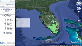
This week, we converted our week 10 dot density mxd on ArcMap to a kmz file that is viewable on Google Earth. This is very useful for communicating data organized in ArcMap with people who are not familiar with the program.
First, we made adjustments to our original map and exported it as a kmz file. The only adjustment I needed to make was simplifying my legend. Then I ran the Map to KML tool and the Layers to KML tool. The Map to KML process took an extremely long time (over ten hours within multiple attempts) and I ran the tool several times concerned that an error had occurred. I enlarged my dot density to try to speed up this process. I ultimately created a new file, copy and pasted my old layers over, and used ArcCatalog for this process, which worked like a charm. Once it was done I was able to open my files on Google Earth.
After I viewed the map in Google Earth, I needed to change the solid fill of the layers to an outline within the program.
Finally, I created a Google Earth tour. This process required me to add placemarks on:
Full map of south Florida
Miami metropolitan area
Downtown Miami
Downtown Fort Lauderdale
Tampa Bay Area
St. Petersburg
Downtown Tampa
Then, I pressed record and manually clicked and zoomed to each location I had placemarked in my table of contents.
This was a fun lab, but converting the map was very frustrating. Overall, this is a very valuable skill for communicating information. I recognize that it is useful for those who don't regularly use ArcMap and for times when one simply needs an overview without the specificity of ArcMap.


Comments
Post a Comment