Posts

Showing posts from January, 2018

Module 2 Lab: Introduction to Graphic Design with Adobe Illustrator

Image
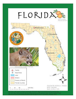
This week, we were expected to make a map on ArcMaps, save it as an AI file, and add design features with Adobe illustrator. The product we were asked to submit was pretty basic, but the learning curve with Adobe Illustrator was quite intense. The first step, creating a map with ArcMaps, was simple and straightforward to me. Unfortunately, after importing the map into Adobe Illustrator, I realized that there were a few compatibility issues. My north arrow was not visible and I needed to remove the mask from each of the layers on my original layer package and "Other 2". I have listed several other problems I encountered below. Hopefully, I will become less inept to dealing with these issues as I become more familiar with the program. Ultimately, I was able to change my city symbols and add the required text and images, but I still feel like I have a lot to learn about the software. Overall, I am very satisfied with the final map I created. I was unable to change the color

Module 1 Lab: Map Critique

Image
This week was the first lab assignment for cartography. We were instructed to find an example of a "well done" map and a "poorly done" map from a variety of sources and recognize elements that we want to include and exclude from our aesthetic throughout our GIS careers. I really enjoyed looking through all the maps and appreciated how a story can be told with very few words. There were several maps that appealed to me, but I felt a lot of them omitted information that was necessary. For example, a global map of racial tolerance did not include country names or the majority race in each area, which seems necessary to communicate a point in my opinion.  The map I ultimately chose as my "well done" map is a map of the world's population concentrated in the United States based in the population density of major cities. This is very interesting to me because it gives one an idea of how crowded or spread out different cities are over a very familiar lan

Welcome to GIS4006

Hello,  My name is Bonnie C. Morris and this is my first blog post of the new semester. I am looking forward to learning even more about GIS and becoming more confident in my skills.  I am from a small town in Georgia, but currently reside in Gainesville, Florida. I am a recent graduate of UF where I majored in Forest Resources and Conservation. I love technology and I chose to learn more about GIS because it combines two areas that I'm interested in. Like many of you, I hope to work in a field that allows me to contribute the knowledge I have gained from these courses. This is my second semester at UWF and so far I have learned a great deal. In my spare time I enjoy watching football and basketball. http://arcg.is/2mvSVsW