Posts

Showing posts from September, 2018

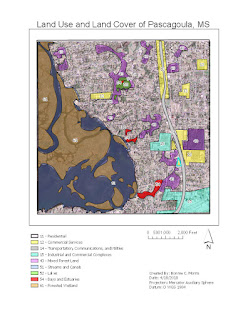
Module 4 - Ground Truthing and Accuracy Assessment

Image
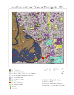
This week, we checked the accuracy of our land cover classifications from last week by conducting an accuracy assessment using the street view on google maps. I used a random sampling method so that I could choose as many unique locations as possible. Because so much of the map falls under the residential and Streams and Canal categories, I felt it was important to verify the smaller areas like Bays and Estuaries, Lakes, etc. were correct. First, I zoomed into the map to select smaller locations (around 20). Then I zoomed out and filled in the gaps with more random points for verification.

Module 3 - Land Use / Land Cover Classification

Image
This week we were instructed to differentiate land uses and classifications on a map using LULC classification. The following is information from my process summary explaining the classifications and how I went about creating each feature: 11 – Residential: (Where people live i.e. apartment complexes, subdivisions, trailer parks, neighborhoods) I labeled areas with small houses spaced sporadically or close together as residential. Because houses were located all over the map, this class takes up the largest portion. 12 – Commercial Services: (Places of business and public service i.e. stores, restaurants, schools, office buildings) I labeled areas by the major road as commercial services because this is typically where those services are located. I also found what appeared as a school, a retail store, and a cluster of uniform buildings with flat roofs as commercial.  14 – Transportation, Communications, and Utilities: ( Areas used for transport and travel ) I labeled the lar

Module 2 - Visual Interpretation

Image
This week, we were tasked with identifying different features and elements of aerial photos in Arc Pro. This was my first time using arc pro extensively and it took quite a bit of patience to figure out how to navigate the program. Ultimately, I did complete my maps, but I will be use provided help from now on! The following information is from my process summary for future reference: Exercise 1 The objective of exercise 1 was to identify different textures and tones on an aerial raster image. I accomplished this by creating polygons that outlined distinguishable areas for each of these criteria including Tone: Very light, light, medium, dark very dark – and – Texture: Very fine, fine, mottled, coarse, very coarse.  This exercise caused me the most trouble because I had never used Arc Pro before. After adding my input files into the folder and reading the instructions and helpful tips from ESRI, I still could not figure out how to create a feature class. Finally af