Posts

Showing posts from February, 2018

Module 6 Lab: Data Classification

Image
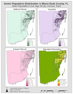
Module 6 was another very informative lab. The requirement was not too intense, but understanding the material required thorough study of the textbook chapters and lecture. We were instructed to make two maps of seniors (people over age 65) in Miami-Dade County, FL using four different classification methods: Equal Interval, Quantile, Standard Deviation, and Natural Break. One map used the percentage of seniors by census tract and the other used the total number of seniors by census tract. Since I knew that the color ramp would need to be changed for standard deviation and because one of the "good example" maps I chose in the first module used this approach, I decided to use different colors for each classification method. In my opinion, this added an additional level of clarity to the map, without taking away from its purpose. The four classification methods I used are defined below. For each, I'll start out with a description in my own words from my process summary

Module 5 Lab: Spatial Statistics

Image
This week we used ESRI training online to learn more about the relationship data location and quantity have with the nature of the information we present in maps. The map below is part of the first exercise. In this section, we were asked to explore spatial patterns in the data using ArcGis. By implementing the provided map and data, I was able to determine directional distribution, median center, and mean center of weather monitoring stations. Knowing where these stations are located and  the trends associated provides more insight to the values they provide.  The mean of these stations shows that while there are clusters of stations located in Switzerland and Austria, the dispersed stations in northern and western regions keeps the mean in the center of western and central Europe.  Likewise, the median is still located towards the center despite the clusters, but it is more influenced by them than the mean.  The directional deviation shows that the eclipse is roughly eas

Module 4 Lab: Cartographic Design

Image
This week, we were asked to create a map that employed features that provide the maximum amount of legibility and clarity. Using Gestalt principles of perpetual organization, I was able to create a map that highlighted schools in Washington D.C. and separated them by elementary, middle, and high schools. Contrast: I used contrast to differentiate the schools by color and size Visual Hierarchy:  To implement visual hierarchy in my map, I ensured that the focal area, Ward 7, was the main point of the map by making it a lighter color than its surroundings and its features more prominent than those in other areas. Next, I made the title, subtitle, and legend the second most important features on the map by their locations, colors, and size. The scale and north arrow, data source, and frame and neatlines are the next most-relevant features, respectively. Figure-ground Relationship: To establish this, I made Ward 7 lighter than the other features on the map to make it appear close

Module 3 Lab: Typography

Image
This weeks topic was typography. In our lab, we were asked to label cities and other prominent features of Marathon, Florida. The first step was creating a basemap on ArcMap that featured a small scale map of Marathon and an inset map that further explained its location. Next, we were instructed to import this into Adobe Illustrator as an AI file. While the lab required a little more knowledge of Adobe Illustrator, I found it much easier to complete and appreciated that confidence in my skills allowed me to experiment with the program and get the look I envisioned. Some features I added to my map were: Text halos, inset map and legend drop shadows, varying font colors and sizes, and two font families. While the map might look simple, it was necessary to closely study the text to understand the correct way to position, size, and implement certain map features as well as what fonts to use. I found it interesting that I followed most of the rules in my previous maps already. I attribut