Posts

Showing posts from April, 2018

Module 12 Lab: Google Earth

Image
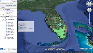
This week, we converted our week 10 dot density mxd on ArcMap to a kmz file that is viewable on Google Earth. This is very useful for communicating data organized in ArcMap with people who are not familiar with the program. First, we made adjustments to our original map and exported it as a kmz file. The only adjustment I needed to make was simplifying my legend. Then I ran the Map to KML tool and the Layers to KML tool. The Map to KML process took an extremely long time (over ten hours within multiple attempts) and I ran the tool several times concerned that an error had occurred. I enlarged my dot density to try to speed up this process. I ultimately created a new file, copy and pasted my old layers over, and used ArcCatalog for this process, which worked like a charm. Once it was done I was able to open my files on Google Earth. After I viewed the map in Google Earth, I needed to change the solid fill of the layers to an outline within the program. Finally, I created a Google

Module 11 Lab: 3D Mapping

Image
This week, we were instructed to use the ESRI training module to learn about 3D maps. I studied their background, the data required to create them, and their applications.  Three dimensional mapping uses TINs, raster data, and z-values to create a map that shows depth. The values can portray proportional elevations of terrain and manmade features such as buildings.  In my process summary, I described why a 3D building map is advantageous: A 3D building layer reveals patterns that are not visible in 2D. As noted in ESRI training, 3D modules can help one visualize how buildings will interact and merge with other buildings and landscaping. They can also help one visualize a route more accurately as the buildings they will encounter can act as landmarks, a feature that is unavailable in a 2D map. There were three major parts of the lab. The first was the focused  solely  on ESRI training using ArcScene which was composed of six exercises.  Exercise 1: We created a map