Posts

Showing posts from November, 2018

Module 10 - Supervised Classification

Image
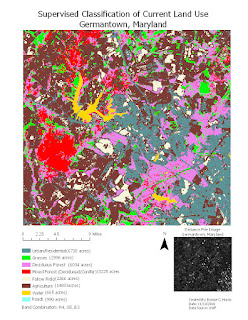
Exercise 4 required me to combine the skills I learned in the previous exercises to create a map detailing the land use for an area in Germantown, Maryland. To create this map, I needed to go back through each of the previous steps to choose the best course of action for this type of map. I created classes for each of the different land uses, addressed any spectral confusion, and then consolidated like-classes. I chose colors for each class that stood out from each other. Finally I opened my map in arcpro, added essential elements, and exported my map.

Module 9 - Unsupervised Classification

Image
In exercise 2, I used ERDAS imagine to manually separate a high resolution aerial image of the UWF campus into classes. Initially, I created 50 classes with the Unsupervised Classification function so that there would be enough classes to clearly translate the image and then consolidated those classes into 5 independent (including mixed) classes using the “Recode” function. I chose to turn the original layer on and off while classifying the image instead of the swipe, flicker, or blend methods, as this was the easiest for me. I did the math to determine how much of the area was permeable an impermeable and wrote the percentages on the map. Towards the end of my map creation, while working in layout view, I ran into the familiar problem of the cursor getting stuck on the rotate function. I restarted Argo Apps several times to fix this issue.