Module 3 - Land Use / Land Cover Classification
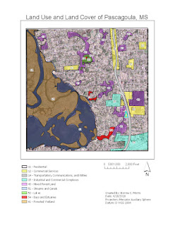
This week we were instructed to differentiate land uses and classifications on a map using LULC classification. The following is information from my process summary explaining the classifications and how I went about creating each feature:
11 – Residential: (Where people live i.e. apartment complexes, subdivisions, trailer parks, neighborhoods) I labeled areas with small houses spaced sporadically or close together as residential. Because houses were located all over the map, this class takes up the largest portion.
12 – Commercial Services: (Places of business and public service i.e. stores, restaurants, schools, office buildings) I labeled areas by the major road as commercial services because this is typically where those services are located. I also found what appeared as a school, a retail store, and a cluster of uniform buildings with flat roofs as commercial.
14 – Transportation, Communications, and Utilities: (Areas used for transport and travel) I labeled the largest highway as an area used for transportation.
15 – Industrial Commercial Complexes: (Areas that display factory or industrial plants) I labeled areas with land clearing and large buildings that are remotely spaced as industrial. These areas appeared like factories or industrial plants.
43 – Mixed Forest Land: (Forest land with mixed species of trees and other foliage) I chose mixed forest land over areas that were densely vegetated with large trees. I chose mixed instead of evergreen or deciduous because it is not apparent what season this image was captured.
51 – Streams and Canals: (Streams and canals are typically found within a wetland area. They are large bodies of water that may branch out into smaller channels) I labeled the water area around the forested wetland as streams and canals because of the nature of its shape.
52 – Lakes: (Large independent bodies of water surrounded by land) There was one large body of water next to two smaller related waterbodies that I chose to label a lake.
54 – Bays and Estuaries: (Areas where a larger body of water extends and then disappears into a larger landmass) There were two areas on the map that I identified as bays. These areas had small slivers of water that extended into the larger landmass. Within and then beyond the lake I identified an estuary.
61 – Forested Wetland: (Land that predominately wet, but displays large tree growth) I chose forested wetland for the island-like areas located within the streams and canals. Although this probably could have been labeled as mixed forest, the lack of man-made structures caused me to interpret that the ground is suitable for trees, but too saturated with water for any construction.


Comments
Post a Comment