Module 2 Lab: Introduction to Graphic Design with Adobe Illustrator
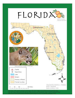
This week, we were expected to make a map on ArcMaps, save it as an AI file, and add design features with Adobe illustrator. The product we were asked to submit was pretty basic, but the learning curve with Adobe Illustrator was quite intense. The first step, creating a map with ArcMaps, was simple and straightforward to me. Unfortunately, after importing the map into Adobe Illustrator, I realized that there were a few compatibility issues. My north arrow was not visible and I needed to remove the mask from each of the layers on my original layer package and "Other 2". I have listed several other problems I encountered below. Hopefully, I will become less inept to dealing with these issues as I become more familiar with the program. Ultimately, I was able to change my city symbols and add the required text and images, but I still feel like I have a lot to learn about the software.
Overall, I am very satisfied with the final map I created. I was unable to change the color of the background directly around Florida because it the state polygon was embedded in the white background, but I did use the ruler and rectangle tools to create a green background around it to demonstrate that I know how to use those tools. I feel it at least contributed to the coherency of the color scheme. I enjoyed the lab this week and appreciate that I can use Adobe Illustrator to add effects to material created in ArcMaps. As discussed in the lab instructions, graphic design skills are extremely valuable and I enjoy being creative with my maps. Hopefully this is a skill I can use to enhance my GIS resume.
Takeaways:
- Make sure the original map in ArcMaps is perfect because it's very difficult to change later. I would essentially need to restart the entire process on Adobe Illustrator (as far as I could tell).
- Some fonts from ArcMap don't translate to Adobe Illustrator. While the font of my legend and scale bar could be changed, Adobe Illustrator didn't recognize the format of my north arrow.
- While I feel much more comfortable with the program than I did when I started, I still had to work around a few issues with the layers. When I grouped certain features together, the layers were unreachable. I used the "Other 2" layer to edit my features a couple of times and I don't feel this was the most effective way.


Comments
Post a Comment