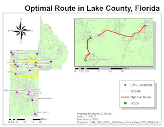
Geocoding - Week 11 Lab
This week geocoded emergency management service sites in Lake County, Florida. By importing data from the US Census Bureau, I was able to network EMS sites with address information. The only problems I encountered during parts 1 and 2 of this weeks lab were with locating addresses that had candidates that didn't match. It was still necessary to use the manual select from the map tool.
The third section of the map required me to use a model builder to set certain parameters that locate areas around schools where gas companies regularly check for gas leaks. I liked this method because it made the steps for creating a map visual.
Section 1: Geocoding – Step 4: Research Locations and
Match Addresses
1.
I right clicked EMS in the TOC and selected “Geocode
Addresses”
2.
I added the MyAddressLocator layer and changed
the Minimum match and candidate score
3.
The first method I used to match the unmatched addresses
was selecting them from the map as this was necessary for the locations with no
candidates.
4.
I used select by attributes to find the streets
and carefully located the specific location of the two addresses with no
candidates and used the bing map to verify they were correct
5.
All but one of the locations with candidates
were easily located when compared to the bing map; however, one of the
locations had points that weren’t close to the bing map point. For this area, I
elected to select the point from the map again. I was able to find the exact
address.


Comments
Post a Comment